Road, cycle trail remain closed due to slip

Staff Reporter
05 June 2024, 4:07 AM
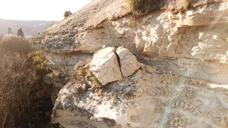
 Drone footage taken yesterday at the site of a 30-40 metre landslip. Photos: Supplied
An unexplained collapse of a cliff onto Livingstone-Duntroon Road has closed the road and part of the Alps 2 Ocean Cycle Trail for an unknown period.
The 30-40 metre section of rock-fall and slip on the east side of the road, between State Highway 83 and Settlement Road, will keep it closed due to a number of reasons, the Waitaki District Council said in a statement this afternoon (Wednesday, June 5).
The site, which includes a section of the cycle trail, was assessed for safety risks by drone and a geotech engineer on Tuesday.
“There are currently a number of precarious boulders and sections of rock remaining with the potential for further slips and falls,” the statement said.
“This fall was not caused by a rainfall event, or by geological activity such as a quake or tremor. With that in mind, simply clearing the material on the road would not be appropriate until the causes have been determined, and action taken to secure or remove the remaining collapsed boulders and rock.”
The cliff itself is property of Ngāi Tahu, and the land behind it privately owned. It is also close to the Maerewhenua Rock Art Site, one of the UNESCO Waitaki Whitestone Geopark sites, the statement said.
The council, stakeholders and contractors are partnering with Ngāi Tahu to assess any historic or cultural significance, and preserve any carvings or rock art within the fall area, and further updates will be provided as they are available.
Diversions
• The A2O is currently being rerouted along Earthquakes Road to rejoin the trail beyond the rock-fall site. This is not a sealed road, so motor vehicle traffic is discouraged.
• Road traffic is encouraged to take the Georgetown–Ngapara road as a diversion to reach Elephant Rocks, Livingstone and other areas usually accessible by the Duntroon-Livingstone Road.
A second drone shot of further potentially unstable rock, where the original slip occurred.