Local Weather with WAL (Waitaki App Limited)

Staff Reporter
19 July 2023, 3:30 AM
 A spectacular sunrise over Oamaru this morning, 19th July 2023. PHOTO: Alex Regtien.
It really has been unseasonably warm in the Waitaki since Friday last week. Ōamaru’s official high temperature on Tuesday 18th hit 19.3 Degrees C!
Of course the mild winter temperatures can’t last forever, so we’re in for a change in the weather from later today. For tomorrow (Thursday) there is a heavy snow watch for the high country south of Lake Tekapo, and some road snowfall warnings are in force overnight, including the Lindis Pass - see below (click to expand).
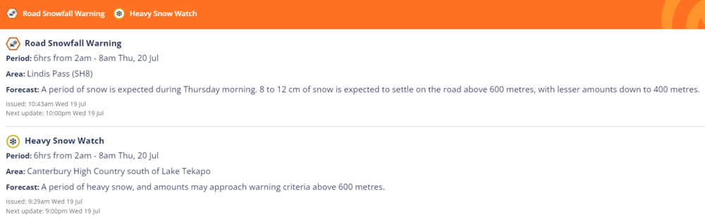
MetService road snowfall warning & heavy snow watch: Issued Wednesday 19th July.
For coastal Waitaki, this means that today we’ll have high cloud, lowering this evening while northwesteries will turn southerly. Temperatures will drop with that wind change, down to about 6C with a few spots of rain overnight.
Thursday’s forecast is for rain, possibly heavy, easing to showers in the afternoon with a high of 10deg C. Fresh southerlies will ease and turn easterly later in the day, dropping down to 4C overnight.
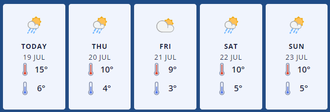
MetService forecast graphic for Ōamaru: Issued Wednesday 19th July.
Friday will be mostly cloudy with some early drizzle and northerlies freshening in the afternoon. Expect a cooler high of 9deg C, down to 3C at night.
Saturday should be cloudy with a high of 10deg C and a low of 5C. Expect some occasional rain developing in the evening with westerlies turning southerly for a period of time.
Sunday is likely to have some early rain followed by fine weather. Westerlies will turn northerly, with temperatures reaching 10C, dropping to 5C on Sunday night.
Up in the Mackenzie Basin, Omarama and surrounding areas have also had a run of warmer weather with Wednesday’s high hitting 14deg C, above the forecast high of 12C. Expect 50km/h northwesterlies and a low overnight of 2C.
Tomorrow things get a bit more wintery, with rain developing in the morning, with snow to 600 metres or possibly lower in sheltered areas, easing in the afternoon with a high of 7deg C. Southeasterlies will increase to 50 km/h in the morning, easing back later and turning easterly in the evening with an overnight low of 0C.
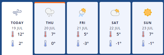
Metservice forecast graphic for Omarama: Issued 19th July
Friday will be colder still, with showers becoming isolated but staying cloudy and a forecast high of just 5deg C, down to -3C overnight.
The weekend up the valley is looking pretty good but chilly. Saturday will be fine with easterlies turning southerly and a high of 5Deg C, down to -1C. Sunday is looking similar, possibly slightly warmer during the day at 7C and down to -1 at night.
For the latest updated forecasts and real time conditions in your local area, click on the Waitaki towns below, or go to the Weather category, next to News|Sport in The Waitaki App!