Local Weather with WAL (Waitaki App Limited)

Staff Reporter
03 July 2023, 4:00 AM
 A fine July day for an icy dip at Friendly Bay! PHOTO: Ethan Reille
Hats off to those who braved the annual Mid-Winter swim in Ōamaru yesterday! Yesterday's official high in town was 7.3deg C, with a sea surface temperature of around 11deg C.
It was certainly a cold and windy weekend in the Waitaki with some brisk windchill and a dusting of snow to elevated areas inland. The week ahead shows some improvement as the weather systems that brought the stormy weather move away and high pressure that is currently over Australia tracks toward us bringing more settled weather.
There are a couple of things to note over the next few days - a strong wind warning is in place for tomorrow (Tuesday 4th) from 6am to 9pm for North Otago, Dunedin and Clutha. Expect severe gale west to southwesterlies gusting 120 km/h in exposed places.
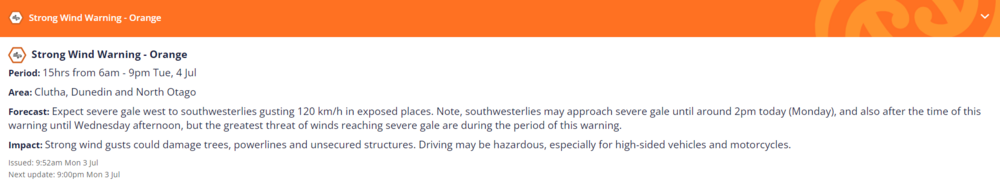
MetService Strong Wind Warning: 6am - 9pm Tuesday 4th July (Click to expand view on mobile).
Also boaties, surfers and beach swimmers beware - big swells are expected to build on the east coast on Wednesday and Thursday so anybody planning to be on or in the water should keep a close eye on the current conditions and latest marine forecasts.
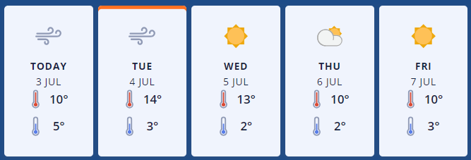
So looking at the week ahead for coastal Waitaki, today is fine with the chance of a shower later. Strong southwesterlies will ease late, with a low of 5deg C tonight.
Tuesday is fine with strong westerlies ramping up to gale force in exposed places (see wind warning above), gusting up to 120km/hr, easing late evening. A warmer high of 14deg C though, dropping to 3 C overnight.
MetService forecast graphic: Oamaru.
Wednesday looks like the best day of the week with sunny skies and a high of 13deg C. Northwesterlies will turn southwesterly in the morning, with a cooler overnight low of 2deg C.
Thursday is another fine one with northerlies developing in the afternoon. Temperatures will sit between a high of 10deg C and a low of 2 C at night. Friday looks similar overall, starting off fine but becoming cloudy during the day and a high of 10deg C.
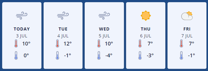
Further inland, the upper Waitaki has been partly cloudy today with a keen southwesterly, dropping to 0 C tonight.
Tuesday looks like it will be fine, but with strong westerlies, gusting gale 70km/hr in exposed elevations, easing back in the evening. A high of 12deg C, dropping to 1 C overnight.
MetService forecast graphic: Omarama
Wednesday will be fine but will have a cooler high of 10deg C. Southwesterlies will ease in the afternoon and there’ll be a drop down to -4 deg C at night.
Thursday should be sunny with southwesterlies dying out and a high of 7deg C, down to -3 in the evening. Friday will be partly cloudy, with northerlies becoming fresh in the afternoon, and a high of 7deg C.
For the latest updated forecasts and real time conditions in your local area, click on the Waitaki towns below, or go to the Weather category, next to News|Sport in The Waitaki App!