Local Weather with WAL (Waitaki App Limited)

Staff Reporter
30 June 2023, 2:00 AM
 MetService graphic: 7 Day cumulative rainfall - 12am Thurs 22rd to 12am Thurs 29th June.
 Coastal Waitaki had a decent spell of rain this week, most of it on Tuesday and Wednesday with official totals of 14.6 and 13.2 mm respectively.
Further up the valley in the southern Mackenzie basin area, rainfall was considerably lighter with Omarama’s official reading for Sunday to Wednesday this week totalling only 6.2 mm.
Looking ahead for the weekend, it’s going to be chilly throughout the region with a strong and unstable south-westerly flow affecting the entire country until early next week. Don’t head out without some extra layers on as the windchill will make it feel much colder in exposed places!
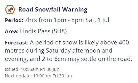
There are a number of Road Snowfall warnings in force for the southern alpine passes so please keep up to date with these if you are driving - see the MetService warning below for the Lindis Pass on Saturday.
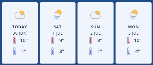
In Ōamaru and eastern Waitaki it’ll be fine today with some afternoon cloud and a high of 10deg C. Southwesterlies will ease this evening with an overnight low of 1deg C.
Saturday will start with morning frosts, and then a few showers may develop in the afternoon with fresh westerlies in the evening. Expect a high of 9deg C, falling to 3 C at night.
MetService forecast Graphic: Oamaru.
Sunday will be fine with a high of 8deg C, falling to 1 C overnight with fresh westerlies easing late. Monday looks like it'll be cloudy with showers possible and a high of 10deg C.
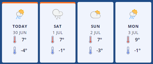
On the western side of the Waitaki district, Omarama’s forecast for Friday is for partly cloudy conditions and isolated showers becoming more widespread this evening with the snow level possibly lowering to 700 metres. Westerly winds will increase in the afternoon and the high will only hit 7deg C, dropping to a crisp -4 C.
On Saturday there will be cloudy periods, with isolated snow showers developing. Westerlies will rise to severe gale 90 km/h about the foothills in the afternoon. Expect an optimistic high of 7deg C, falling to -1 C on Saturday night.
MetService forecast graphic: Omarama.
Sunday looks mainly fine with southwesterlies, and a high of 7deg C, and an overnight low of -3 C.
Monday will be mostly cloudy with some isolated snow showers developing. Southwesterlies could rise to gale force about the foothills with a high of 9deg C, falling to -1 C overnight.
Next week high pressure will move in over the south so it's looking great for the first week of the school holidays!
For the latest updated forecasts and real time conditions in your local area, click on the Waitaki towns below, or go to the Weather category, next to News|Sport in The Waitaki App!