Local Weather with WAL (Waitaki App Limited)

Staff Reporter
25 June 2023, 9:25 AM
 Sunset from Glen Warren Reserve, Sunday 25th June. PHOTO: Alex Regtien
It looks like it’s going to be a bit of a mixed bag this week, but conditions should improve by Friday.
On Monday, Ōamaru and coastal Waitaki will have a period of wet weather in the morning, followed by fine spells and a high of 13deg C, dropping down to 5 C at night.
On Tuesday, cloud increases in the morning followed by afternoon rain with some heavy falls possible. Southerly winds will become fresh with similar temperatures to Monday.
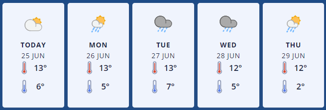
MetService forecast Graphic: Oamaru.
Wednesday will start with early rain, some heavy, easing by lunchtime. Light winds with a high of 12deg C, and a low of 5 C at night.
Thursday sees lingering showers clearing but cloudy skies remain with westerlies and a high of 12deg C. At this stage Friday's forecast is for sunny weather but it’ll be cooler, with a high of only 10deg C, dropping down to 2 C overnight.
Up in Omarama there’s a similar pattern for the week, with northwesterlies, rain and isolated showers on Monday. Snow will be possible down to 1600m with a high of 10deg C, down to 1 C at night.
Tuesday sees rain and a southerly developing in the afternoon with snow possible to 1200m, easing later. Temperatures will sit between 9deg C during the day and 1 C at night.
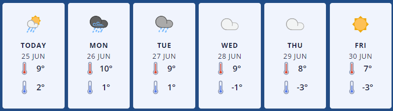
MetService forecast Graphic: Omarama.
Wednesday will be overcast with isolated showers and southwesterlies developing. Temperatures should be similar to Tuesday, but slightly colder overnight with -1deg C.
Thursday will be overcast with isolated showers and southwesterlies again, but even colder with a high of 8deg C, down to -3 C. On Friday the sun should come out (hurrah!) accompanied by northwesterly winds and a high of 7 deg C.
For the latest updated forecasts and real time conditions in your local area, click on the Waitaki towns below, or go to the Weather category, next to News|Sport in The Waitaki App!