Local Weather with WAL (Waitaki App Limited)

Staff Reporter
30 May 2023, 12:25 AM
 Sunset from Glen Warren Reserve last week. PHOTO: Alex Regtien
After a fairly mild weekend on the Waitaki coast, the week ahead looks like more of the same.
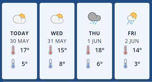
Mostly northerly winds will keep daytime temperatures in the mid to upper teens, and overnight lows between 3 and 8 degrees.
Some high cloud and a few spots of rain here and there may spoil some mostly fine days. On Thursday a northwest flow over the Alps will bring unseasonably warm temperatures to Otago and Canterbury for the first day of Winter, until rain develops late with a fresh southerly change.
Friday will become fine, with showers developing later in the day and northerlies turning westerly.
Metservice forecast graphic: Oamaru
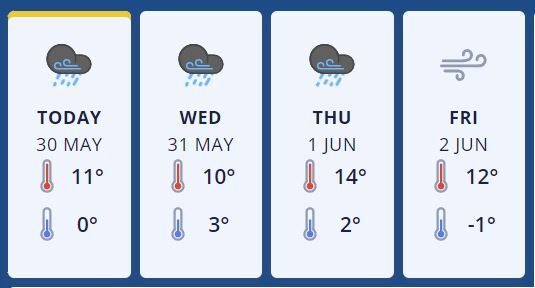
Up the mighty Waitaki Valley at Omarama, things aren’t looking quite as benign with Tuesday’s forecast being scattered afternoon rain clearing in the evening, with strong to severe gale northwesterlies at higher elevations.
Wednesday sees possible showers, with strong to gale northwesterlies at higher elevations and rain falling as snow above 1300 metres at first. Rain will spread from the divide later in the day on Thursday, with snow to 2200 metres and northwesterlies rising to severe gale.
Metservice forecast graphic: Omarama
Friday will bring occasional showers with snow lowering to 900 metres, easing later in the day. Severe gale northwesterlies will turn gale southwest early on. Daytime temperatures for the week will sit in the low to mid teens, dropping to lows of between 3 to -1 degrees.
See the latest updated forecasts and real time conditions for the towns below.