Local Weather with WAL (Waitaki App Limited) - 24th July 2023

Staff Reporter
24 July 2023, 3:45 AM
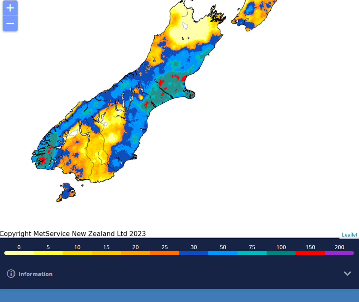 MetService 7 Day Cumulative Rainfall map: 24th July (click on map to expand on mobile).
What a soggy Sunday in the Waitaki district! After a relatively fine start to the weekend an intense stream of moisture was delivered to eastern areas of the South Island, with the Canterbury region bearing the full brunt of the downpour.
Akaroa recorded a massive 245mm of rain from midnight Friday to 6am Monday, while the Canterbury skifields gratefully welcomed their first big dump of snow this season, Mt Hutt receiving a monstrous 70cm at the base area and over 1 metre at the summit!
Unfortunately Otago skifields weren’t in the firing line of the storm, but there’s plenty of winter left and there may be some more snow to be had this week.
For the Waitaki it certainly wasn’t a record breaking amount of rain, but it was the biggest rainfall event for a while, with Ōamaru officially recording 55.8mm from Saturday evening to midnight Sunday. There was more rain in that period than in all of May and June combined.
So what’s in the forecast for the rest of the week? New Zealand will see a change to southwesterlies with an unsettled, showery weather pattern.
The first of several cold fronts is expected to cross the country during Tuesday and Wednesday bringing strong, cold southwesterlies and thundery showers to New Zealand. Snow is expected to lower to 400-600 metres in the far south overnight Tuesday. There is also a MetService Road Snowfall Warning for the Lindis Pass late Tuesday afternoon.
Area: Lindis Pass (SH8)
Period: 3hrs from 3pm - 6pm Tue, 25 Jul
Forecast: Brief snow is forecast to 800 metres on Tuesday late afternoon or evening, and up to 1 cm of snow may settle on the road.
Another round of strong winds and showers is forecast as a second front moves northward over the country from late Wednesday.
So for coastal Waitaki, we’ll see occasional showers and southerlies dying out by this evening and a low of 4deg C.
Tuesday will start with low cloud and fog clearing away to a fine morning and a high of 13 deg C. Cloud and southwesterlies will build in the afternoon and there’ll be a brief period of showers as that front charges up the country, with an overnight low of 4C overnight.
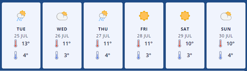
MetService 6 day forecast graphic for Ōamaru.
Wednesday is looking nice to start with a high of 11deg C, but cloud will build in the evening while southwesterlies will turn northwest in the afternoon, dropping to 3C at night.
Thursday is forecast to have cloudy periods and a high of 11deg C, with a few showers possible and southwesterlies possibly rising to to gale during the afternoon and evening, down to a low of 4C.
Friday looks great - fine and 11deg C with southwesterlies easing and a low of 3 C. At this stage the weekend should be nice and settled with daytime high temperatures of 10deg C, dropping to around 3C at night.
Up at 411 metres above sea level, Omarama will see periods of rain possible with snow to 1400 metres, clearing this evening and dropping to 0deg C.
Tuesday is looking mostly cloudy and will get to a high of 10deg C, with a period of showers in the afternoon and evening and snow possible to 700 metres, down to -2C overnight.
Wednesday will be cloudy again with a high of 9deg C and isolated showers possible at either end of the day. It’ll get windy later, with some gale northwesterlies developing about the foothills, down to -1C at night.
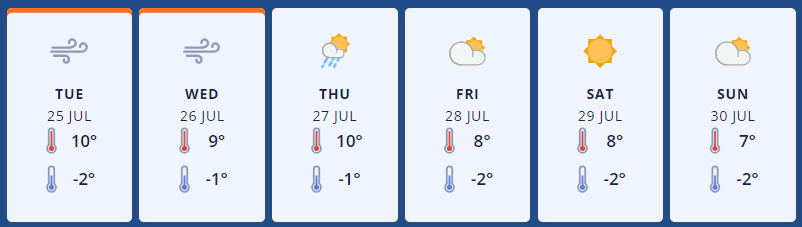
MetService 6 day forecast graphic for Omarama.
Thursday will see showers become isolated with those gale northwesterlies turning strong to gale southwest - a high of 10deg C and a low of -1C.
Friday will be partly cloudy with isolated showers clearing and a high of 8deg C, southerly winds will turn westerly and the overnight low will be -2C.
The weekend is looking promising - fine with light winds, maybe a bit of cloud on Sunday and similar temperatures to Friday.
For the latest updated forecasts and real time conditions in your local area, click on the Waitaki towns below, or go to the Weather category, next to News|Sport in The Waitaki App!