East coast the place to be over next few days
Staff Reporter
07 November 2024, 1:22 AM
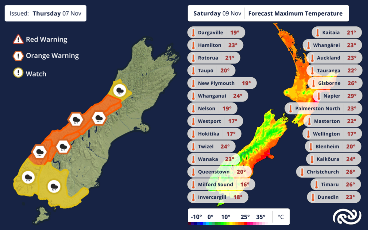
 Sunshine is predicted for the South Island's east coast, and heavy rain for the west. Image: MetService
It will be warmer than usual for early November over the coming days, MetService predicts.
The weather for most of Aotearoa for the next few days is looking dry, aside from the odd shower, which is mainly about inland areas.
Northerly winds are transporting warmer air this way, increasing temperatures country-wide, but most distinctly in eastern areas from today (Thursday) through until Saturday.
Most places can expect daytime highs in the low twenties, with some east coast areas getting into the high twenties – four to eight degrees Celsius above average for this time of year, MetService meteorologist Dan Corrigan says.
Overnight temperatures are unlikely to drop below the low teens in the eastern South Island, which is also a significant departure from the norm, while some spots in Hawkes Bay might hit 30 degrees on Saturday, for the first time since last summer.
Meanwhile, persistent heavy rain is expected to reach the rest of the South Island overnight tonight (Thursday) into Friday morning, affecting the West Coast, Southern Alps, and the deep south.
Orange Heavy Rain Warnings are in place for Westland, northern Fiordland, and the Main Divide of the Southern Alps south of Arthur’s Pass, Dan says.
“Intense rainfall may cause streams and rivers to rapidly rise on both sides of the Main Divide, as 300-400mm of rain is expected to fall about the Westland Ranges and Canterbury headwaters within a little over a day.
“These are substantial numbers, even for the West Coast, so it’s certainly worth preparing in advance by moving stock and planning for potential travel restrictions,” he says.
Meanwhile, Heavy Rain Watches have been issued for southern Fiordland, Southland, eastern Clutha, and Grey – all with a moderate chance of being upgraded to an Orange Warning.
This rain will ease on Saturday before moving northwards to affect the lower North Island overnight into Sunday (Warning amounts are not expected).


